
How to Navigate Using a Map and Compass

In an age where GPS devices and smartphones are ubiquitous, the art of navigating using a map and compass can seem almost antiquated.
However, this traditional skill remains invaluable, especially for hikers and trail enthusiasts who venture into areas where technology might fail or lose signal.
Knowing how to navigate using a map and compass not only enhances your connection with the natural world but also ensures your safety in remote areas. In this article, we'll explore the essential steps and techniques for mastering this crucial outdoor skill.

Understanding How to Navigate Using a Map and Compass
The ability to navigate using a map and compass is an essential skill for anyone who enjoys spending time in the wilderness.
Whether you're embarking on a multi-day hike in the mountains or simply exploring a local trail, understanding the basics of map reading and compass use can make the difference between a successful adventure and a disorienting ordeal.
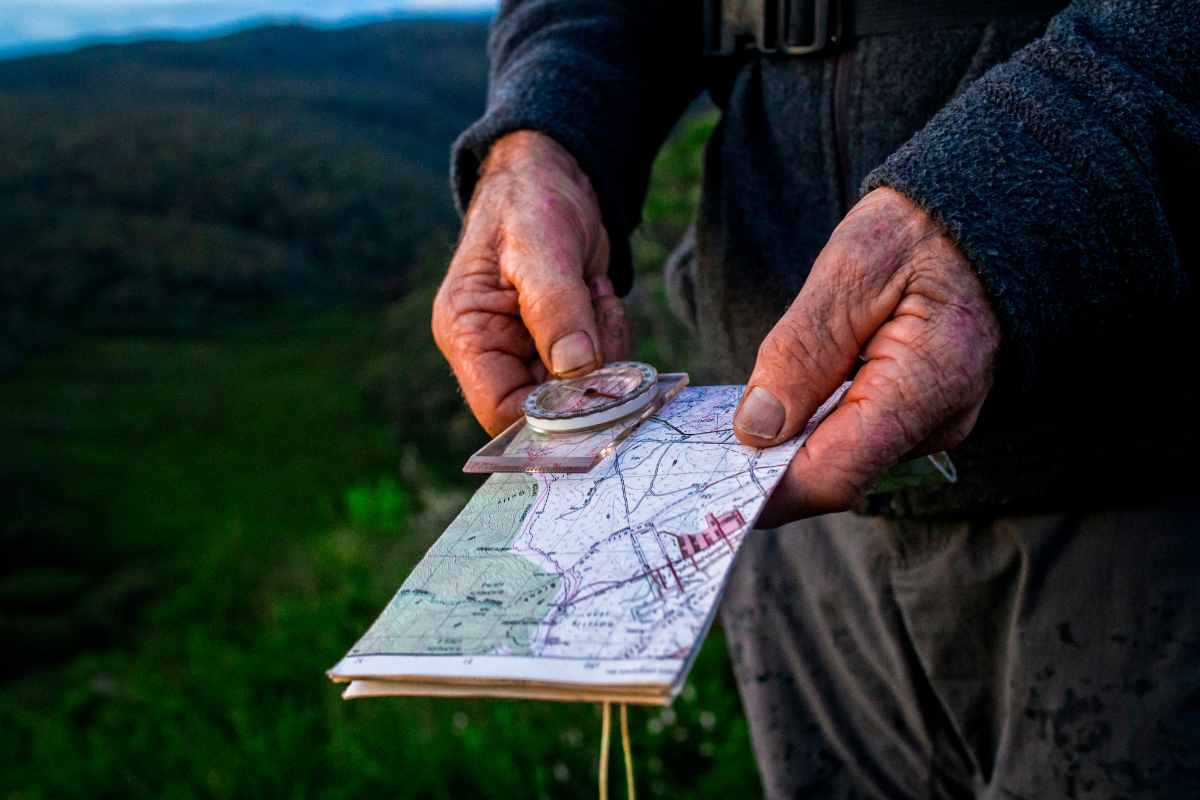
A compass is a simple yet powerful tool that shows direction relative to the Earth's magnetic poles.
Combined with a topographic map, which represents the terrain with contour lines and symbols, the compass allows you to determine your exact location and plot a course to your destination.
Mastering these tools will give you the confidence to explore new trails, even in unfamiliar terrain.
Essential Tools for Navigation
To navigate using a map and compass effectively, you need to familiarize yourself with the key tools involved. First and foremost is the compass itself.
A basic orienteering compass, which includes a rotating bezel (the circular, numbered ring) and a magnetic needle that points to magnetic north, is typically sufficient for most hiking needs.
You should also have a topographic map of the area you're exploring, which provides a detailed representation of the landscape, including elevation changes, water bodies, and significant landmarks.
Before setting out on your hike, ensure that your compass is functioning correctly. This includes checking that the needle moves freely and that there are no magnetic interferences that could cause inaccurate readings.
It's also important to understand the concept of declination—the difference between true north (geographic north) and magnetic north. This difference varies depending on your location, and it must be accounted for to ensure accurate navigation.
Reading a Topographic Map
A topographic map is a specialized map that shows the three-dimensional features of the terrain on a two-dimensional surface.
Contour lines are used to represent elevation—each line connects points of equal height. The closer together these lines are, the steeper the terrain.
By understanding contour lines, you can get a sense of the landscape's shape, including hills, valleys, ridges, and depressions.
Other important features on a topographic map include water bodies (lakes, rivers, streams), trails, roads, and landmarks like buildings or towers. Familiarizing yourself with these symbols and how they are represented on the map is crucial for effective navigation.
Setting the Map
One of the first steps in navigating using a map and compass is to orient your map. This means aligning your map so that the directions on the map correspond to the directions on the ground.
To do this, lay the map on a flat surface and place the compass on top of it. Rotate the map and compass together until the compass needle points to the north on the map.
This process is called setting the map, and it ensures that what you see on the map matches what you see in the environment around you.
Taking a Bearing
A bearing is the direction from your current location to your destination, expressed as an angle relative to north. To take a bearing, first, identify your location on the map and then locate your destination.
Place the edge of the compass along the line between these two points, ensuring that the direction-of-travel arrow on the compass is pointing towards your destination.
Next, rotate the bezel of the compass until the north marker on the bezel aligns with the north on the map. The number at the top of the bezel is your bearing.
Once you have your bearing, you can use the compass to keep you on course as you move towards your destination.
It's important to periodically check your bearing and adjust your course as necessary, especially when navigating through dense forests or over rugged terrain.
Following a Bearing in the Field
Once you've taken your bearing, the next step is to navigate using a map and compass in the field. Hold the compass flat in your hand at chest level, ensuring that the direction-of-travel arrow is pointing straight ahead.
Rotate your body until the magnetic needle aligns with the orienting arrow on the compass. This alignment indicates that you are facing the correct direction.
As you begin to walk, keep an eye on the compass to ensure that the needle remains aligned with the orienting arrow. This will help you stay on course, even if the terrain obscures your view of distant landmarks.
In open areas, you can also use visual cues, such as trees or rocks, to help guide you along your bearing. Simply pick a point in the distance that lies along your bearing and walk towards it.
Once you reach that point, take another bearing to the next landmark and continue on your path.
Correcting for Magnetic Declination
As mentioned earlier, magnetic declination is the angle between magnetic north and true north. Failing to correct for declination can result in significant navigational errors, especially over long distances.
The amount of declination varies depending on your location and is typically indicated on the map's margin.
To correct for declination, you need to adjust your compass before taking a bearing. If your map indicates an east declination, you will need to subtract the declination value from your bearing.
For a west declination, you add the value. Some compasses have a built-in mechanism for adjusting declination, while others require manual calculation. Always double-check your calculations to ensure accuracy.
Navigating Around Obstacles
When navigating using a map and compass, you may encounter obstacles such as rivers, cliffs, or dense vegetation that block your path. In these cases, it's essential to know how to adjust your route while still maintaining your overall bearing.
One common technique is called handrailing, which involves using a linear feature like a river or ridge as a guide. By following this feature, you can bypass the obstacle while staying on course.
Another technique is aiming off, where you intentionally aim to one side of your destination when approaching an obstacle.
This ensures that when you reach the linear feature (such as a trail or river), you know which direction to turn to find your destination. After bypassing the obstacle, you can take a new bearing to get back on your original course.

Practice Makes Perfect
Becoming proficient at navigating using a map and compass takes practice. Start by practicing in familiar areas where the stakes are low.
Over time, you’ll build the confidence and skills needed to navigate more challenging terrain. Consider joining an orienteering group or taking a wilderness navigation course to further develop your abilities.
It’s also important to practice under different conditions, such as low visibility, nighttime, or varying terrains. This will help you become more adaptable and prepared for any situation you might encounter on the trail.
The Importance of Staying Oriented
One of the key aspects of successful navigation is staying oriented at all times. As you hike, make it a habit to regularly check your position on the map and confirm that you’re still on the correct course.
This is particularly important when hiking in areas with few landmarks or when traveling off-trail. If you ever become disoriented, stop immediately, and use your map and compass to re-establish your location.
The Essential Skill of Navigation
Learning to navigate using a map and compass is a fundamental skill for any outdoor enthusiast. While modern technology has made navigation easier, the reliability and simplicity of a map and compass cannot be overstated.
By mastering this skill, you’ll be able to explore the wilderness with confidence, knowing that you can find your way even when the unexpected happens.
In addition to enhancing your outdoor experiences, knowing how to navigate using a map and compass is an essential safety measure.
Whether you’re on a remote mountain trail or exploring a dense forest, these tools are your best allies in ensuring a safe and enjoyable adventure.
So, grab your map and compass, head out to the trails, and practice this timeless skill that connects us to the great outdoors.
Did you find this post useful or inspiring? Save THIS PIN for later in your Outdoor Board on Pinterest! 😊

Explore these outdoor tips too